


SnifferDRONE™ is Top Performer in Independent Methane Detection Study
Updated: Aug 28

In the 2025 controlled release testing hosted by Flux Lab at the Petrolia Landfill SIMFLEX facility, Sniffer (DroneSEM) delivered the strongest overall localization performance across all technologies.
Sniffer excelled in the controlled release experiment.
Part 1: Understanding the Experiment.
Sniffer was invited to participate in five experiments (22, 24, 27, 34, and 35), each limited to 90 minutes. These experiments involved emissions studies over a twenty-acre area of a closed landfill, designed to emulate a landfill with isolated methane emissions. The site, located in Petrolia, Canada, is designed to simulate landfill emission by releasing pure methane gas at point sources on an actual landfill.
Sniffer maximized its time on site to achieve as much sampling as possible within each 90-minute experiment, achieving 3.75m spacing – a case study in the speed and efficiency that can be achieved with the SnifferDRONE. 3.75m spacing allows Sniffer to downsample the data to emulate all multiples of 3.75m spacing, including all known regulatory spacings (7.5m / 25’; 15m; and 30m). See Part 3 of this post, where the data are downsampled to show equivalent performance at 7.5m and nearly identical performance at simulated 11.25m spacing.
Don’t mistake this experiment for OTM-51 compliance testing.
Sniffer was not permitted to perform OTM-51; Method 21 requires secondary inspections of increased meter readings; these secondary inspections were not allowed by the hosts.
Later in this series of blog posts, we will model OTM-51 results from the SnifferDRONE data collected in these experiments.
Of the 5 experiments, 2 were cut short.
· Experiment 24 was abruptly stopped after ~40 minutes to pivot to a satellite release.
· Experiment 35 was abruptly stopped after ~20 minutes for “test infrastructure issues”.
Localization Results:
Sniffer scored the highest amongst all technologies for localization of emissions. (Figure 1 – DroneSEM, far right column). Sniffer had a strong majority of true positives, more than any other technology. Sniffer was assigned one false positive and two false negatives. Additionally, Sniffer had the least percentage of both false positives and false negatives.

Three Representative Detections:
Figure 2 shows three representative emissions from the SnifferDRONE at Petrolia, ranging from the smallest emission (center, 4.1kg/hr) to the 2nd largest (right, 50.92 kg/hr). In each plume, concentrations above 25ppm are colored yellow and concentrations above 200ppm are colored red. The Sniffer reported emission location is identified as a blue circle. 200ppm is a critical concentration in the application of OTM-51, where 200ppm is the increased meter reading concentration that requires manual inspection per Method 21 (not performed in this experiment).
Note how in each experiment multiple SnifferDRONE passes identified concentrations above 200ppm, even in the lowest emission rate seen. Unlike typical landfill emissions, the 25ppm plume extends well past the actual emission location. While the SnifferDRONE flies, it infers the wind direction and velocity based on the relative pitch and roll required to stay on the defined path. The wind roses for experiments 27 (first two plumes of Figure 2) and experiment 34 (right-most plume in Figure 2) are shown in Figure 3; the plumes are well aligned with the wind directions of the wind roses.


Experiment 27 showed the second largest emission at 50.92kg/hr from release location E, with the plume obfuscating an emission from release location B (13.65kg/hr). The SnifferDRONE measurements showed concentration enhancement in the combined plume and Sniffer therefore correctly reported 2 distinct emission locations. The extent and size of this plume is believed to be the largest Sniffer has ever recorded. The maximum recorded concentration at this release location was 15,623ppm; It is the 24th highest concentration Sniffer has recorded in its previous 500 site surveys (spanning over 10M data points).
Overall, the Petrolia results confirm that SnifferDRONE™ performed exceptionally well in controlled release testing, but this post is only the starting point. The headline result is clear: DroneSEM delivered the strongest localization performance in the study, even with two experiments cut short and without the full OTM-51 workflow being allowed.
In the next posts in this series, we will dig deeper into what the data shows, detailing our false, positive, both false negatives and real fugitive emissions found during the experiments.
Part 2: How Much Path Spacing is Enough? Down-sampling SnifferDRONE™ Results at Petrolia
In Part 1 of this series, we reviewed the headline result from the 2025 controlled release testing hosted by Flux Lab at the Petrolia Landfill SIMFLEX facility: SnifferDRONE™, reported as DroneSEM, delivered the strongest overall localization performance across all participating technologies.
In this post, we look at one of the most important practical questions for landfill methane monitoring: how close together do survey paths actually need to be to reliably identify emission locations?
Bootstrapping to Wider Path Spacing
As described in Part 1, Sniffer achieved 3.75 m path spacing within the allotted 90-minute experiments. This dense data collection was not just useful for the initial survey results; it also created an opportunity to evaluate wider path spacings after the fact.
Because the original survey was flown at 3.75 m spacing, the dataset can be down sampled to emulate multiple independent surveys at wider spacings, including 7.5 m, 11.25 m, 15 m, and 30 m (depicted in Figure 4). This allows us to ask a simple but important question: if Sniffer had flown wider paths, would the same emissions still have been detected?

From the plume images published in Part 1, the total number of adjacent flight passes with methane concentrations exceeding 200 ppm were counted for each emission plume. The 200 ppm threshold is important because it represents the increased meter reading threshold used in OTM-51 to trigger a Method 21 secondary inspection. The number of adjacent passes above 200 ppm was then used to estimate the effective minimum path spacing required to locate each emission.

The results are summarized in Table 2. Detection performance was identical at 3.75 m and 7.5 m spacing. Performance worsened only marginally at 11.25 m spacing, with an approximately 19% reduction, and remained strong at 15 m spacing, with an approximately 27% reduction. This is notable because 15 m spacing is Sniffer’s standard study spacing.
As expected, detection efficacy decreases as path spacing gets wider. However, the down sampled Petrolia results show that very tight 3.75 m spacing was not required to detect most emission locations. The dense spacing was valuable because it allowed this analysis to be performed, but the data suggest that practical survey spacings at 7.5 m have equal performance and wider spacing up to 15 m can still provide strong detection performance.
Conclusion

The Petrolia dataset shows the value of collecting dense, high-resolution methane measurements. By flying at 3.75 m spacing, Sniffer was able to evaluate how detection performance changes as the same data are down sampled to wider survey spacings. The result is encouraging: detection performance was unchanged at 7.5 m spacing and remained strong at 15 m spacing, Sniffer’s standard study spacing.
This does not mean path spacing is unimportant. It means that path spacing only matters if it is actually achieved in the field. The Petrolia data show that wider spacing can still produce strong detection performance when survey paths are consistent, controlled, and software-guided. In Part 3, Sniffer will take a closer look at the assigned false positive and two false negatives, and explain why the published scoring does not tell the full story.
Part 3: When the Scorecard Meets the Field: Interpreting SnifferDRONE’s Petrolia Exceptions
In Part 1, SnifferDRONE™ was shown to be the top localization performer in the 2025 SIMFLEX controlled release study. In Part 2, we showed that detection performance remained strong even when the dense 3.75 m flight data were downsampled to wider path spacings. In Part 3, we look behind the scorecard. Sniffer was assigned one false positive and two false negatives, but each of those results requires context: the false positive was a conservative call explicitly flagged for follow-up, while both false negatives occurred during a truncated experiment with incomplete coverage. Just as important, SnifferDRONE identified real methane signals that appear to have been outside the controlled release scoring framework, including a likely surface emission and a leaking valve box. The result is a more complicated, and more useful, lesson: controlled studies are valuable, but real landfill methane emissions are messier than the scorecard can show.
The Assigned False Positive: A Conservative Field Call:
Sniffer was scored with one false positive associated with emission location D3 on Experiment 27. This is the only plume with a meaningful increase in the concentration as a function of downwind distance from the reported emission location and no reasonable explanation. The upwind SnifferDRONE pass peaked at 205ppm, the next pass to the north peaked at 295ppm; both locations are marked with blue dots on Figure 5. Total release rate was 13.65kg/hr.
Sniffer therefore conservatively noted another potential emission location. This reflects a core principle: when data indicates a potential source, the correct operational response is to investigate. The following language was provided, verbatim, to Flux Lab:
“Observed slight discrepancy in the expected plume gradient from EXP27_1- this is flagged as unusual and would certainly be inspected manually to confirm separate leak or transient puff from EXP27_1”
For this point, even with annotation, the northern point was scored as a False Positive because it exceeded the allowed distance from the true emission location.

Controlled release studies depend on clean scoring rules, but field decisions are made under uncertainty. In real landfill work, a suspicious methane signal is not ignored because it falls outside a scoring radius; it is flagged for follow-up. That distinction matters when interpreting Sniffer’s assigned false positive and false negatives.
Two False Negatives:
Both reported false negatives occurred during Experiment 35, which was terminated after ~20 minutes due to test infrastructure issues. As a result:
One location was only partially sampled
One location was not sampled at all
Sniffer’s first false negative occurred at emission D4 (6.2 kg/hr), shown in Figure 10, and was driven by incomplete data collection following an early termination of the experiment.
Pass A, the critical transect required to bound the plume and establish localization, was interrupted when all flights were halted. Pass B, two transects to the north, showed no methane concentrations above 25 ppm despite being surrounded by elevated readings (the only instance in this testing where transects above 200ppm were separated by a transect with less than 150ppm). In a blinded study, with knowledge there was a release infrastructure issue, Sniffer opted not to report.

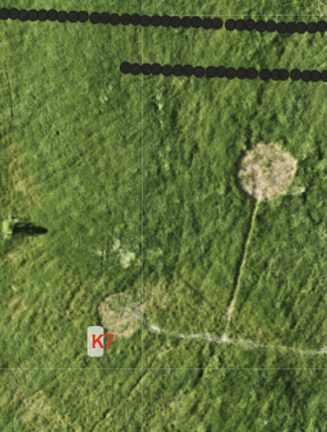
The second false negative also comes from Experiment 35. Sniffer reported a geojson where Sniffer performed sampling in the cutoff experiment; emission location K7 (5.32 kg/hr) was outside of this geojson but was scored as a false negative - Figure 7, an obvious scoring error. Sniffer has reached out to Flux Lab and eagerly awaits an erratum to the EREF report and accurate results reported in any peer-reviewed publication.
Real Fugitive Emissions:
During the sampling campaign, Sniffer inspected the southwest corner of the SIMFLEX-designed study area in the three full-duration experiments (22, 27, 34). Every single time, the SnifferDRONE recorded elevated concentrations in an area with dead vegetation; the maximum concentration measured was 435 ppm. These are real, and real looking, surface emissions collocated with dead vegetation.
Sniffer believes it is the only technology to have identified this emission location.
Why?

In the south-central section of the survey area, the Sniffer team is confident a controlled release valve box, or a similar piece of landfill infrastructure just north of emission point K6, was leaking methane.
In experiment 27 Sniffer noted that the emission looked different than all other release points in the study except the aforementioned landfill gas surface leak; it had high peak concentrations on each of the three passes (927ppm, 824ppm and 582ppm ) but no defined plume (Figure 9). Emission point K6 (to the immediate south) was not active during experiment 27.
In the next experiment, 34, emission point K6 was emitting at 13.5kg/hr; northerly winds pushed the emission point plume atop the valve box. A discrete enhancement was observed in the concentration of the plume at an identical location to experiment 27, with concentrations up to 11807ppm (>25% LEL; Figure 9).
Sniffer’s pilots observed that most controlled release points were located within mowed circles, which appear to significantly affect plume behavior. Releases into short, open vegetation tend to form a localized gas pocket and disperse into a well-defined plume from the mowed area.
The fugitive emission at the valve box, however, was embedded directly in taller vegetation with no mowed clearing (Figure 10). In this configuration, methane was retained within the vegetation canopy and shielded from wind, resulting in a stronger and more persistent near-surface signal.


SIMFLEX is a controlled environment, and the scoring reflects that. The only scored false positive was a conservative call that was explicitly flagged for follow-up, and both scored false negatives occurred in a truncated experiment with incomplete coverage. Those details don’t change the outcome, but they do highlight that test design plays a role in how results are framed.
Sniffer Robotics remains concerned that conclusions from SIMFLEX will be used beyond the scope and limits of the experimental design. SIMFLEX is releasing lighter-than-air natural gas from point sources in mowed circles of a single substrate. Landfills release heavier-than-air landfill gas from varying source geometries with and without visual indicators across dozens of different substrates with varying surface roughness. SIMFLEX is an excellent pilot scale test; The industry needs both lab and scale (in-situ) data to analyze interference factors for all technologies as well as full site studies with M21 validation to make broader conclusions about a technology’s real-world performance. This is where SnifferDRONE separates itself: with tens of thousands of missions and field-validated datasets, where the detections are verified with M21 secondary inspection.
Importantly, the reported results for both DroneSEM (Sniffer Robotics) and MGSEM (Flux Lab) are not compliance datasets – both are the first step in a two-step process of the full, published compliance methods. In the next part of this series Sniffer will model the secondary inspection step atop the SnifferDRONE and MGSEM data to simulate OTM-51 and M-21 performance for the 2025 SIMFLEX controlled release; stay tuned.
Part 4: Reconciling SnifferDRONE’s excellent performance to “MSEM” poor performance
In the first three posts in this series, we looked at SnifferDRONE performance during the Petrolia controlled release testing. We also downsampled the SnifferDRONE data to evaluate performance at different path spacings.
That downsampling exercise created an obvious next question.
When the SnifferDRONE performance is compared to the MSEM data at equivalent path spacing by FluxLab, the results do not match....
Why?
That question matters because the Petrolia MSEM data are already being discussed as evidence of poor “manual SEM” performance. SEM has a regulatory meaning. So before these data are used, in nearly any context, it needs to be clear about what was actually tested.
What a Regulatory SEM Survey Includes
A regulatory landfill SEM survey is not just a methane detector moving across the surface. It has four key elements:
Near-surface inlet height: The probe inlet must be kept 5-10cm (2-4 inches) to the landfill surface.
Required path spacing: The landfill surface must be traversed at the required spacing, dependent on jurisdiction
Secondary investigation of increased meter readings: When the meter reading increases, the operator is required to slow down, investigate the area, and identify the maximum meter reading.
Inspection of visual indicators: The operator is required to inspect visual indicators of emissions such as cracks, penetrations, seeps, distressed vegetation, exposed waste, and other cover defects.
Those elements are what make SEM a source-finding method rather than just a path-following methane survey. At Petrolia, neither SnifferDRONE nor FluxLab were performing a full regulatory method. Visual indicators were not allowed as part of the controlled release test. For the SnifferDRONE, secondary inspection of increased meter readings was not allowed. FluxLab also chose not to investigate increased meter readings or visual indicators during its walking surveys.
That means the comparison is very straightforward: both surveys collected near-surface methane measurements along target paths spacing which have been normalized via downsampling. If those conditions are similar, why are the results different?
There are really only two plausible explanations: Path spacing and nozzle height.
Path Spacing: What Was Actually Covered?
The first issue is path spacing. Spoiler, the walking paths look like half-eaten plates of spaghetti.
The FluxLab walking surveys were described as nominal path spacing of 7.5 m, 15 m, and 30 m. But nominal spacing is not the same thing as actual coverage. Sniffer Robotics processed the walking paths by buffering each path by the stated spacing and clipping the result to the inspection boundary. This gives a simple audit metric: how much of the test area was actually covered at the claimed spacing?

Figure 12: Walking SEM coverage per experiment.
The 30 m walking surveys were generally well covered. The tighter-spacing surveys were not. At 7.5 m spacing, the average coverage was only about 72.5%. That means more than a quarter of the inspection area was missed on average. The lowest 7.5 m survey covered only 65.0% of the test area.
That does not make the data useless. But it does mean the 7.5 m walking results should not be treated as if they represent complete 7.5 m coverage of the test area.
If a source is missed in a survey that missed 20–35% of the area, the interpretation becomes difficult.
Was the source missed because the method is insensitive?
Because methane did not reach the probe?
Because the threshold was too high?
Because the operator did not investigate increased readings?
Because the survey path did not actually cover the area?
Those are different explanations with very different implications.
For comparison, we processed the SnifferDRONE paths the same way.
Experiment | Path Spacing | Total Area | Covered Acres | Missed Acres | Coverage |
22 | 3.75 m | 19.22 | 17.84 | 1.38 | 92.8% |
24* | 3.75 m | 19.22 | 6.66 | 12.56 | 34.7% |
27 | 3.75 m | 19.22 | 17.41 | 1.82 | 90.5% |
34 | 3.75 m | 19.22 | 17.78 | 1.44 | 92.5% |
35* | 3.75 m | 19.22 | 6.72 | 12.51 | 34.9% |
Table 3: SnifferDRONE coverage per experiment. *Note that the two "false Negatives," or undetected controlled release emissions, occurred in Exp 24 and 35 which were cut short by Flux Lab.
Figure 13: DroneSEM coverage per experiment.
*Two of the SnifferDRONE surveys had low coverage because those experiments were cut short by the hosts. For the completed surveys, SnifferDRONE achieved 90.5–92.8% coverage at 3.75 m spacing. That is a tighter path spacing than the walking surveys, with higher completed-survey coverage. This is the result of automation. For compliance monitoring, Sniffer Robotics justifies every gap of missed coverage or goes back and gap fills to attain 100%.
The path spacing explains part of the difference, but it probably does not explain all of it; the SnifferDRONE at 15m outperformed Flux Lab MSEM at 7.5m.
Nozzle height is the only remaining variable
The SnifferDRONE drags the sample inlet directly on the landfill surface. That creates a very consistent near-surface sampling height, especially in the homogenous well managed grass at Petrolia. A walking probe depends on the operator maintaining the required height while walking across uneven landfill cover, following the grid, watching the instrument, and navigating terrain.
That is hard to audit after the fact.
To be clear, we do not currently have data proving the actual inlet height used during each walking survey. That is part of the problem. Path spacing can be audited from GPS data; nozzle height usually cannot. The SnifferDRONE is compliance by default; walking surveys are compliance by fine motor control and lack of fatigue.
The Right Way to Use the Petrolia Walking Data
The Petrolia walking data are useful. They are controlled release data collected under field conditions, but they should not be used as a regulatory SEM baseline. A compliance SEM survey requires all four key elements: near-surface inlet height, required path spacing, investigation of increased meter readings to find the maximum meter reading, and inspection of visual indicators.
This distinction is important because references are already being made to poor MSEM performance at Petrolia to justify alternative methane detection technologies. Alternative technologies should absolutely be tested. Many of them are promising. But they should not be justified against a baseline that is being called SEM while not performing the core functions of SEM.
Sniffer Robotics encourages FluxLab to clearly define the method they performed and to avoid using “SEM” in the name unless the survey includes the core tennants of SEM.
The industry needs that distinction.


Comments